
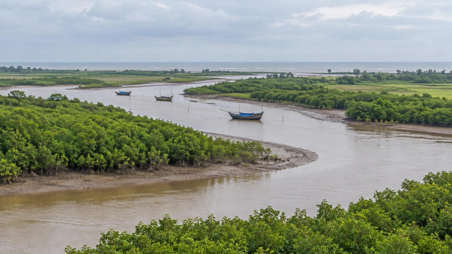
In Bhadrak, water is more than a backdrop. It marks a district boundary, carries soil from inland hills, nourishes paddy fields and meets the tide in a maze of channels. The same rivers connect shrines, fishing communities and the memories of a once-busy port.
This is a useful district to travel through slowly: not simply as a route to a better-known sanctuary, but as a place whose own landscape and history deserve attention.
District overview & geography
Bhadrak became a separate district on 1 April 1993, having previously been a subdivision of undivided Balasore. The district administration places Balasore to its north, Jajpur and the Baitarani to its south, Keonjhar to its west, and Kendrapara and the Bay of Bengal to its east. Bhadrak town is the headquarters. These boundaries are useful when planning excursions: an ecological region can extend across them even when a destination belongs to a neighbouring district. Bhadrak district profile
Much of the district is a low, gently sloping alluvial plain. The older alluvium of the northwest gives way to younger deposits, floodplains and, towards the coast, tidal flats and creeks. A district survey describes former river channels and meander scars within the younger plain: reminders that waterways have shifted over long periods, laying down sand, silt and clay as they move. The coast is not simply the point where land ends; it is a broad meeting place of river sediment and tidal water. Bhadrak district survey report
The Baitarani rises around Gonasika in Keonjhar and marks part of the Bhadrak–Jajpur boundary. The Salandi is another major river of the district. The Genguti, Kochila, Mantei and Kapali belong to a wider network of branches and connected waterways; lower down, distributaries contribute to the Dhamara estuary. The district gazetteer describes both the Baitarani and Salandi branching into deltaic systems. Read these not as separate lines on a map but as a connected landscape in which rivers carry water and sediment from inland catchments towards the Bay. Their channels and distributaries shape the plain over long periods; the district survey’s accounts of former channels and meander scars make that movement visible in the land itself. At the coast, river water meets tidal influence, so the estuary is a transition rather than a sharp boundary. This helps explain why journeys between neighbouring settlements can be shaped as much by bridges, roads and crossings as by straight-line distance. The gazetteer is a record of geography and history, not a live navigation chart: it cannot establish today’s water level, safe crossing or road condition. A map helps make sense of the landscape, but even a map cannot make all these waters stand still. Odisha district gazetteer: Bhadrak
Agriculture remains central to the district’s life, with paddy the principal kharif crop. The administration also identifies fishing as a livelihood in coastal areas including Dhamara, Chudamani and Chandbali. Fields and fisheries should not be treated as picturesque scenery detached from the people who work them: they are productive places, affected by freshwater flows, salinity, storms and access to markets.
Bhadrak’s climate is generally hot and humid. May is typically the hottest month, the monsoon generally arrives in June, and much of the annual rain falls between June and October. December is usually cooler. These are seasonal patterns, not forecasts. Heavy rain can make low-lying roads difficult and rivers hazardous; cyclonic weather can affect travel well beyond the immediate shoreline. District profile
Mangroves and the living estuary
The Bhadrak Wildlife Division describes mangrove vegetation along the district’s coast. Its historical account also records community-linked planting and restoration work in the Chandbali and Basudevpur ranges. Those records show a long-standing conservation effort, not a guarantee that a particular plantation is accessible or in a particular condition today. Bhadrak Wildlife Division
The district survey lists mangroves including Avicennia alba, Avicennia marina, Avicennia officinalis and Sonneratia alba. Salt-tolerant plants are suited to a place where tides and freshwater interact. Mangrove roots can slow moving water and hold sediment, while the muddy channels between them create habitat for small aquatic life. The survey describes a wider web that includes crabs, prawns, mudskippers and fish; it also records fishing cats, otters and water monitor lizards in the broader mangrove habitat, and crocodiles in rivers including the Baitarani, Mantei and Salandi. These species belong to different parts of a varied landscape, not to a guaranteed checklist at one viewpoint. The Bhadrak Wildlife Division’s account of planting and restoration gives the living coast a human history too: conservation work takes place within settlements and working waterways, not apart from them. A visitor can appreciate the system without entering it—watching from a permitted public place, keeping to firm ground and leaving plants, mudflats and wildlife undisturbed. The available district records describe habitat and management history; they do not confirm a current sighting, a specific open trail or access to a plantation.
These records describe habitat, not promised sightings. Look from a safe, permitted place, preferably with binoculars. Do not enter mudflats, disturb roots or approach wildlife for a photograph. Crocodile habitat is one reason not to swim or wade in estuarine water, even when a bank looks quiet.
Mythological & historical significance
Bhadrak’s name is popularly associated with Maa Bhadrakali. The district presents this as a belief rather than an established linguistic proof. At her shrine near Aharapada, the black-granite goddess sits in a lotus posture on a lion. The administration notes that interpretations of the image differ: the name suggests Kali to some worshippers, while the lion invites comparison with Durga. Such differences are part of the life of a sacred place, not a puzzle a visitor must settle. Maa Bhadrakali
The medieval political history is more firmly anchored in dynastic chronology, though local summaries necessarily simplify a changing region. The district history places Bhadrak under the Eastern Ganga dynasty from 1211 to 1436 and the Suryavamsi rulers from 1436 to 1568. It describes Bhadrak as a dandapat, or administrative division, under the Gangas. These are political periods, not dates for every temple a visitor sees today. District history
The same history connects the Vaishnava teacher Chaitanya with Kuansh and Santhia and relates a tradition concerning bedding left at the Madan Mohan temple. This is valuable evidence of local devotional memory. It should not be used, without further corroboration, to reconstruct every detail of the teacher’s movements. A visitor who asks about the tradition may encounter a history preserved through worship as well as through texts.
At Dhamara, the district’s account of Maa Dhamarai offers a different kind of story. In one folktale, the goddess was cast into the sea by her sisters, recovered in fishermen’s nets and subsequently worshipped. The account also tells of a queen’s dream and a temple associated with the Kanika ruler Sailendra Narayan Bhanjadeo; it says an earlier structure was lost to the sea. The tale gives the shrine a maritime setting, but its miraculous events belong to belief, not documented coastal history. Maa Dhamarai
The district’s modern history includes the Quit India movement. At Eram on 28 September 1942, police fired on a gathering; the district account names Pari Bewa among those killed and records 28 deaths at the site and another subsequently. The memorial is a place of mourning and political memory, not merely a stop on a sightseeing circuit. Eram district account
Chandbali’s history is tied to another movement: the circulation of goods and passengers. The district gazetteer describes its importance as a port during British rule and its later decline as rail and road transport grew. It records rice among exports and cloth, kerosene, salt and other goods among imports. Read together, those details suggest a port connected both to local agricultural production and to supplies arriving from elsewhere; the river was part of an economic network, not merely a scenic edge to the town. The gazetteer does not offer a modern timetable or a complete account of every merchant and vessel, so the scale of that trade should not be exaggerated. What it does preserve is a useful comparison: when rail and road links gained importance, the balance between modes of transport changed. That history helps make sense of a present-day proposal for a new cross-river connection without confusing the proposed project with an operating service. It also invites a more attentive visit: notice how the river, settlement and routes fit together, while remembering that the same waters remain part of working lives today. The story is not that modern transport erased the river, but that it changed the river’s place in regional commerce. Bhadrak gazetteer
Tourist Destinations & Hidden Gems
Chandbali: A town at the water’s edge
Chandbali is a good place to begin understanding Bhadrak’s relationship with the Baitarani. The gazetteer places the town on the river’s left bank and describes its former role in trade and passenger movement. Today, a visit need not depend on finding a surviving colonial structure or booking a boat: the value of the place lies equally in understanding why a river port mattered here.
From an appropriate public viewpoint, consider the river as a working route rather than an empty panorama. In a low delta, water can connect settlements while also requiring careful crossings. Goods once moved through a network that joined inland production to coastal trade; the arrival of railway lines changed those calculations. The district gazetteer’s port history supplies context that a quick drive through town can otherwise miss.
Chandbali is also described by the district as an entry point towards Bhitarkanika. That does not put the national park in Bhadrak: Bhitarkanika National Park is in neighbouring Kendrapara. A journey there is a separate protected-area visit, subject to forest-department rules, permissions and weather. The district’s older boat and facility information is not proof of present operations. Confirm the authorised entry point and transport before making plans. District entry-point page
Dhamara and the goddess of the coast
Dhamara brings together a shrine, an estuary and a port landscape. The district’s road directions identify an approach from Jamujhadi on NH 16; arrange local transport and check the route rather than assuming that a road shown on a map gives access to the waterfront. Port premises, jetties and working areas may be controlled. Observe signs and do not enter or photograph restricted areas without permission.
Maa Dhamarai’s shrine gives a cultural dimension to this coastal setting. The district’s account preserves the story of fishermen recovering the goddess and of a temple later affected by the sea. It also reports that the deity was worshipped under a thatched roof during an intervening period. This layered account distinguishes the continuity of devotion from the changing structures that house it.
A respectful visit begins with the temple’s own guidance: ask where photography is allowed, follow instructions about footwear and offerings, and avoid obstructing worship. The shrine is not an observation platform for the port, and the port is not a recreational beach. Allow enough time to return by road without relying on an unconfirmed crossing.
Kaninali and the idea of a crossing
Kaninali, on the Bhadrak side of the Dhamara, is important to the district’s current transport story. Talachua, on the opposite bank, is in Kendrapara. The proposed roll-on/roll-off passenger, or RoPax, jetty project was conceived to connect the two banks for people and vehicles. Its interest for a traveller lies in what it reveals about delta geography: two places that look close across water can require a much longer route by land.
This is not a recommendation to arrive expecting a ferry. The latest verified project status discussed below did not establish that the new service had begun. Nor does a project document confer access to construction sites or jetties. If a crossing is essential to your itinerary, confirm current, authorised operations directly and make a road alternative before departure. Press Information Bureau, 16 April 2021
Maa Bhadrakali: A shrine close to town
Near Aharapada, southwest of Bhadrak town, Maa Bhadrakali is among the district’s principal sacred places. The district gives a route from Kacheri Chhaka via Santhia and Utarabahini. It describes the goddess’s black-granite image and the differing interpretations of her identity. That combination of a recognisable image, a lived ritual tradition and an unsettled question of interpretation makes the shrine a rewarding introduction to Bhadrak’s religious culture.
The temple’s antiquity should not be inferred simply from the age of worship. Local belief about the district’s name, the image’s identity and the present structure’s construction are different questions. The sources consulted do not establish a reliable construction date for the present building. Ask locally about current visiting arrangements rather than treating published hours as a guarantee. District shrine page
Aradi: Akhandalamani beside the Baitarani
At Aradi, Baba Akhandalamani is worshipped as Shiva near the Baitarani. The district tourism list places the shrine within Bhadrak’s religious landscape, while the district survey identifies Aradi in relation to Chandbali. The river setting matters: this is not an isolated architectural object, but a place reached and sustained by regional networks of pilgrimage. District tourist places
Local accounts connect the shrine’s earlier worship with the discovery of a stone and associate the later temple with rulers of Kanika. Treat the discovery story as sacred tradition, not an archaeological finding. The sources consulted do not securely establish a construction date for the present temple, so a visitor should be wary of an exact age offered without evidence.
Shivaratri, locally called Jagar, and the pilgrimage season of Shravana are important to worshippers. Their calendar dates change; verify the relevant year and local arrangements before planning around a gathering. Even outside festivals, dress modestly, ask before taking photographs and leave space for people who have come to pray.
Eram: A landscape of remembrance
Eram, also called Raktatirtha, lies beyond Basudevpur. The district describes a meeting field bounded on several sides, a geography that became tragically important when police fired on the Quit India gathering in 1942. The site’s natural setting is therefore inseparable from its history: the banks and approaches are not simply scenery around a monument.
The district’s account records 29 deaths in all, including Pari Bewa. The gazetteer also recounts the killing of boatman Kusha Tarai at Chudamani before the force reached Eram. Its description of the immediate deaths differs in detail from the tourism page’s account of when the final victim died. The shared evidence establishes the firing and its grave toll; the sequence should not be flattened into an invented certainty. District gazetteer
Read the memorial inscriptions if accessible and give the place the quiet attention it deserves. A visit here provides a counterpoint to the district’s shrine and river routes: Bhadrak’s heritage also includes collective resistance and the cost paid by local people.
Palia and the inland route
Palia village, on the route towards Chandbali, is identified by the district as the location of Sri Biranchinarayan Temple. It provides a worthwhile inland contrast to the estuary: a religious stop within the agricultural plain rather than a coastal viewpoint. The district lists it as a historic attraction, but a listing alone does not establish the date of every part of the structure or its current visitor arrangements. District tourist list If including Palia, check the route and temple arrangements locally, and resist the temptation to turn the day into a race between shrines. A shorter itinerary allows time to understand how villages, fields and roads connect with the river country farther east.
Recent news & tourism developments
The Kaninali–Talachua project remains an unresolved travel question. On 16 April 2021, the Press Information Bureau announced approval for a RoPax jetty project and associated infrastructure connecting the two banks. Its original estimate was ₹110.60 crore; the proposed reduction in journey time was a projection, not a timetable. PIB announcement
A Rajya Sabha answer dated 21 July 2026 gave the project cost as ₹136.98 crore and listed physical progress at 81%, with the status “under implementation”. It recorded an expected completion date of 10 September 2026. That date had passed by this edition, but the evidence checked did not verify completion or the start of the new passenger service. The July figures are a dated progress report, not a present-day construction update.
The same parliamentary answer lists a road connection from Jamujhadi on NH 16 to Dhamra port via Basudevpur as under planning. It should not be described as completed work or assumed to be the route’s present condition. The distinction matters locally: infrastructure can change access to a coastal district, but a proposal does not by itself change how a visitor can travel today. Recent severe weather is a reminder to check current notices before any coast trip. The IMD’s 20 November 2026 evening bulletin, issued after severe cyclonic weather, forecast light to moderate rain or thundershowers at one or two places in Bhadrak through 8:30 a.m. IST on 22 November, with no separate district warning listed for that period. By this article’s scheduled publication time, the forecast period will have passed; it says nothing about conditions after 8:30 a.m. or whether a route, jetty or beach is open.
On 18 November, Odisha’s Information and Public Relations Department reported temporary suspension of beach tourism and restrictions at unsafe coastal points through 20 November in view of the cyclone. That dated notice records a temporary measure; it does not establish whether any particular activity remains restricted or has reopened. Check current IMD, district administration and disaster-management advisories before travel, and follow local instructions.
Traveler essentials
Getting there and getting around
By air: Biju Patnaik International Airport in Bhubaneswar is the practical airport named by the district and Odisha Tourism. Continue towards Bhadrak by road or arrange onward rail travel. Published distances differ, so use a current route map for your actual starting point rather than relying on a single kilometre figure.
By rail: Bhadrak railway station is the useful railhead for the district. Check current train stops and bookings with Indian Railways. A railway line associated with port freight should not be assumed to provide a passenger connection to Dhamara. Bhadrak travel directions
By road: NH 16 links the Bhubaneswar–Cuttack side with Bhadrak. From town, local roads lead towards Aharapada and onward districts and coastal settlements. The district identifies the Chandbali approach from Bhadrak and the Dhamara approach from Jamujhadi; verify the exact road, vehicle arrangement and condition before setting out. Do not calculate a tight connection around an unverified ferry.
A practical visit can use Bhadrak town as a base for Maa Bhadrakali and Palia, with a separate day towards Chandbali and Aradi. Eram and the Dhamara coast merit their own planning rather than being squeezed into the same afternoon. These are suggestions, not promises about travel times or access. For accommodation, Odisha Tourism names Panthanivas Chandbali and mentions hotels and guest houses in Bhadrak and Chandbali; confirm availability and suitability directly. Odisha Tourism
When to go and how to visit
Odisha Tourism suggests October to March as a general travel window. Cooler conditions can make road travel and temple visits more comfortable, but October and November are not exempt from severe weather. The monsoon brings a different view of the fields and rivers, along with greater potential for flooding and disruption. In any season, the latest local warning is more useful than a seasonal average.
In temples, follow the instructions of staff and worshippers. At memorials, keep voices and photography respectful. In villages and fishing areas, ask before photographing people or equipment, and leave paths and working spaces clear. Carry water and take waste back with you; do not leave food or plastic near waterways.
For any protected-area excursion, contact the relevant forest authority about current entry rules, permitted routes and authorised operators. Never pursue turtles, crocodiles or nesting birds, enter a restricted shoreline, or assume a calm-looking channel is safe for swimming. If a boat trip is officially available, check weather, operating permission and safety equipment before boarding; do not pressure a crew to travel in unsuitable conditions.
What to eat
Bhadrak’s culture page names palua ladu and chhena mudki among sweets associated with the district. Ask local sweet shops what they have made that day rather than assuming either will always be available. Odisha Tourism also identifies pakhala, fermented rice, and dalma, a lentil-and-vegetable preparation, alongside coastal fish and prawn dishes as foods encountered in the area. These are part of a wider Odia food culture, not inventions exclusive to Bhadrak. Odisha Tourism food guide
Ask about ingredients, freshness and spice levels, especially for seafood, and choose food prepared and stored safely. A meal in town, a conversation about a shrine and a careful look at the river can reveal as much about Bhadrak as a long checklist. Here the most rewarding itinerary follows the connections between land and water without assuming that every bank is a destination or every channel a route.
Publishing Metadata & Tagging
- Group: Odisha Tourism
- Section/Category: Society And Culture
- Destination: https://pcachary.in
- District: Bhadrak
- Edition: 2026-11-21
- Cycle: 2
- Tags: Odisha Tourism; Bhadrak; Society And Culture
Sources & checks
Evidence checked 21 November 2026. Dates below are publication or document dates where known; undated district pages may change.
- Bhadrak district profile and district history, Government of Odisha: geography, livelihoods and dynastic history.
- Bhadrak district gazetteer and district survey report, Bhadrak administration: rivers, port history, ecology and historical transport. The survey contains conflicting internal figures; precise forest and population totals are not used.
- Bhadrak Wildlife Division: mangrove management and historical restoration.
- Bhadrak administration: tourist places, Maa Bhadrakali, Maa Dhamarai, Eram, Bhitarkanika entry point, culture and travel directions. Eram accounts differ on the sequence of deaths; older access details are not treated as live.
- Bhadrak destination guide, Odisha Tourism: season, food and travel approaches.
- RoPax project announcement, Press Information Bureau, 16 April 2021; Rajya Sabha answer 307, Ministry of Ports, Shipping and Waterways, 21 July 2026. The parliamentary answer was retrieved from a cached copy; later completion and operation remain unverified.
- Evening weather bulletin, IMD Bhubaneswar, 20 November 2026; coastal safety notice, Odisha Information and Public Relations Department, 18 November 2026. Neither establishes current access.
- Cover: Original text-free cover image generated for this article on 21 November 2026; no third-party image is used.
Disclaimer
This content is a collection of ancient history,books and various articles and collection of library and news and other post ; all details may not be the same. Readers are requested to verify the information themselves. Readers are not allowed to take any disciplinary action; content is only for educational purposes. If readers do not agree about the contents, they may send a personal comment to my personal email ID: achary.purna@gmail.com
