
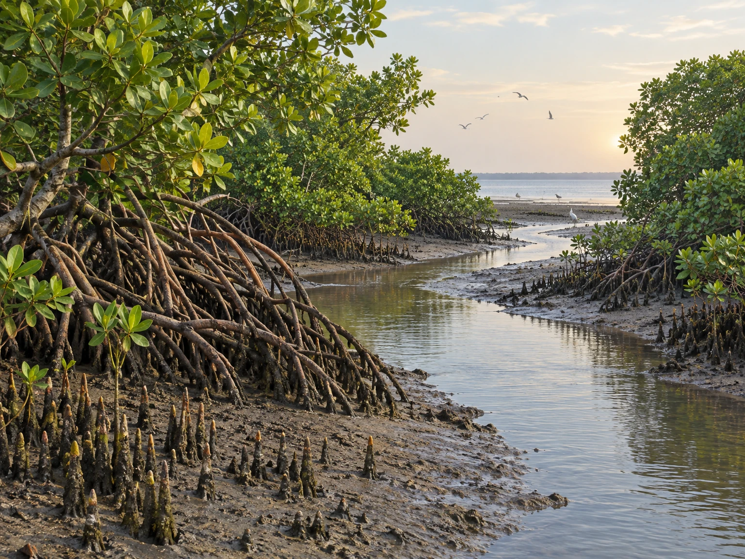
Odisha’s coast is not a single unbroken wall of mangrove forest. It is a changing mosaic of estuaries, river mouths, tidal flats, creeks, mud, sand, salt-tolerant vegetation and settlements, shaped by the meeting of rivers with the Bay of Bengal. Mangroves occupy places where tides regularly bring saline or brackish water and where plants can endure waterlogged, oxygen-poor soils. Their roots, leaves and growth patterns make them conspicuous, but their importance lies just as much in the less visible connections among water, sediment, plants, animals and people.
This guide introduces the ecology of Odisha’s mangroves, with particular attention to Bhitarkanika and the wider delta landscapes identified in the state forest department’s pictorial guide. It explains how tidal forests work, why different species grow in different places, what mangroves can and cannot do for a coast, and how conservation can be made more durable. A 2014 ecological study of four Bhitarkanika sanctuary sites is used as a useful example of local variation, not as a census of the entire Odisha coast. The central lesson is simple: mangroves are living systems, not interchangeable plantations, and good protection begins by understanding each site.
1. A forest between land and sea
Mangroves are trees, shrubs and associated plants adapted to the tidal margins of tropical and subtropical coasts. Their habitat is defined less by a line on a map than by repeated conditions: saline or brackish water, changing water levels, soft sediment and periods when roots are submerged. A site may be flooded by a tide, exposed to air, soaked by rain or influenced by freshwater flowing down a river. The balance shifts with season, rainfall, river discharge, tides and local landforms. That variability is a basic feature of mangrove life.
Their setting is also a boundary between ecological worlds. A mangrove creek carries water and fine particles through a network of channels. On its margins, plants catch light and draw nutrients from sediment and water. Fallen leaves and other organic matter enter food webs; small animals use roots and shallow channels as shelter, while fish and crustaceans move between habitats as conditions change. Birds and reptiles use the wider wetland in different ways. No single tree explains the whole ecosystem. The forest functions through relationships among species and physical processes.
In Odisha, this coastal forest is part of an inhabited landscape. Villages, fishing grounds, farmland, roads, embankments and protected areas sit alongside rivers and tidal wetlands. Conservation therefore has to consider both ecological processes and the choices that shape land and water use. A map can show a forest patch; it cannot by itself show whether a creek still exchanges water freely, whether a natural stand is regenerating, or whether people can meet their needs without damaging the habitat.
2. Odisha’s coastal pattern
The Odisha Forest Department’s Mangroves of Odisha: A Pictorial Guide describes mangrove areas associated with the Mahanadi delta, the Brahmani–Baitarani delta around Bhitarkanika, and the Balasore–Bhadrak coast. The guide also discusses the influence of several river systems, including the Mahanadi, Brahmani, Baitarani, Devi and Budhabalanga. Those names help orient a reader, but they should not be taken to mean that every river mouth contains the same habitat or that a mangrove belt has a simple, fixed boundary.
River water carries sediment and fresh water toward the coast. Tides move seawater and brackish water inland and back out again. The shape of the estuary, the height and arrangement of its banks, the presence of islands and mudflats, and the opening of channels all influence how long water remains in a place. A creek that receives regular tidal exchange can differ sharply from a shallow depression that has become isolated. Two nearby stands may have different salinity, soil texture, inundation time and plant communities.
This is why the word “mangrove” can describe a broad coastal ecosystem rather than one uniform forest type. A local description should say which delta, creek or division it concerns and should distinguish mapped forest, protected-area boundary and surrounding wetland. The Forest Department guide gives an accessible introduction and species-identification material; detailed management decisions still require current local maps, field observations and the relevant division’s plans. Geography is not a decorative background to the biology. It sets the conditions the plants must live with.
3. Bhitarkanika in context
Bhitarkanika is the best-known mangrove landscape in Odisha and an important part of the state’s coastal wetland heritage. The Forest Department’s guide describes it in relation to the Brahmani and Baitarani delta and notes its protected-area setting. A Government of India information release on Ramsar sites lists Bhitarkanika Mangroves as an Odisha wetland of international importance; the forest guide records its Ramsar designation in 2002. These labels matter because they signal recognised conservation value, but they do not replace everyday habitat care or establish that every part of the wider delta has identical legal status.
The place is a network of water and land: tidal channels, creeks, mudflats, forested banks, river edges and connected wetland habitats. A visitor may see only a small stretch from a boat or a viewing point, while plants and animals respond to conditions across a much larger catchment. A wetland boundary and an ecological boundary are not always the same. Water, sediment, wildlife and human activity can cross administrative lines, so planning for a site benefits from coordination among forest managers, local communities and other agencies responsible for rivers, fisheries, land and coastal waters.
Research also cautions against treating Bhitarkanika as one homogeneous stand. Upadhyay and Mishra’s 2014 paper, “An Ecological Analysis of Mangroves Ecosystem of Odisha on the Eastern Coast of India,” examined four sanctuary sites—Bhitarkanika, Dangmal, Thakurdia and Kakranasi. It reported differences in dominant tree layers between river-bank and interior areas and recorded 29 species across its study sites, with only eight common to all four. These numbers describe that study’s locations and methods; they are not a current, coast-wide species inventory. The variation is the important point: small-scale setting matters.
4. Tides set the daily rhythm
A mangrove forest experiences an alternating rhythm of inundation and exposure. During a flood tide, water enters creeks, spreads across some low surfaces and reaches the bases of trees. At ebb tide it retreats, leaving sediment, organic material and small pools behind. The timing and height of tides vary, and the flow through a channel depends on its shape and connection to the larger estuary. A low site can be flooded more frequently than a slightly higher one; a blocked or altered channel can change the pattern even where the regional tide remains unchanged.
For plants, inundation presents several simultaneous challenges. Water around roots slows direct access to oxygen, while dissolved salts create a physiological burden. The substrate may be soft and unstable. The same tide that creates stress also moves nutrients and propagules, carries organic matter, and links the forest to adjacent aquatic habitats. Mangrove plants are not simply “water-loving” in the ordinary sense: they are adapted to a specific set of stresses and opportunities, and each species has its own tolerances.
For animals, tides influence where food and shelter are available. Some organisms use shallow channels or exposed mud at particular stages of the tidal cycle. Fish and invertebrates may move with water between creeks, banks and open water. Birds feed in habitats that become accessible as the water falls or rises. These movements are one reason an isolated stand can lose ecological value even if its trees remain alive. Connectivity—water moving through the channels and organisms moving among habitats—is part of the habitat itself.
Understanding this rhythm is practical, not merely academic. A restoration plan that plants seedlings without asking whether tides can reach the site may fail. A channel modification intended for one use can alter inundation elsewhere. Before intervening, managers need to know the site’s elevations, water pathways, seasonal variation and existing vegetation. Where possible, protecting natural tidal exchange and observing how a site responds is safer than assuming that planting alone can repair an altered hydrology.
5. Mud, salt and low oxygen
Mangrove soils are often fine-grained and waterlogged. Water fills spaces between sediment particles, reducing the movement of oxygen into deeper layers. Roots in such soils face a different problem from roots in well-drained ground: they need to anchor the plant and take up water and nutrients while coping with limited oxygen. Sediment can be deposited, resuspended or eroded as water moves. Organic matter from leaves and other sources is broken down in an environment that can be oxygen-poor, and the resulting soil conditions vary from one patch to another.
Salinity is also variable. The Odisha Forest Department guide describes mangrove waters across a broad salinity range and notes that some habitats can become hyper-saline. That statement is a general description of possible mangrove conditions, not a measurement for every Odisha creek or for a particular day. Rain and river flow can dilute water; evaporation and weak flushing can increase salt concentration. The relevant question for any site is not “is it salty?” but how salinity changes across place and season and how that change interacts with waterlogging, soil and plant species.
These conditions help explain why mangroves should not be judged only by the number of trees planted. If water has been cut off, the soil surface altered, or a channel drained, seedlings may encounter conditions outside their tolerance. Conversely, a site with natural propagule arrival and suitable tidal flow may regenerate without large-scale planting. A useful assessment records water depth and duration, salinity, sediment stability, species composition, natural seedlings and signs of stress over time.
Simple observations can complement formal science. Residents, fishers and field staff may notice when a creek stops flushing, when a bank begins to erode, or when seedlings appear after a change in flow. Such observations are not substitutes for measurement, but they can guide where monitoring should focus. Combining field knowledge with repeatable measurements makes it easier to distinguish a temporary seasonal change from a more persistent alteration. That distinction matters before deciding whether a site needs protection, repair or simply time to recover.
6. How mangrove plants cope
Mangrove plants show a variety of structural and physiological adaptations to saline, waterlogged and low-oxygen settings. The Odisha Forest Department guide describes these adaptations and illustrates several species. One familiar feature is the exposed root system. Some mangroves develop prop roots that brace trunks and branches against soft substrate and moving water. Others have roots that rise above the mud or water surface, creating visible structures through which gas exchange can occur. These forms are not interchangeable, and not every mangrove species has the same root arrangement.
Leaves are another part of the adaptation story. Salt entering a plant can disrupt water balance, so species differ in how they limit, tolerate or manage salt. Some have leaf features that reduce water loss; others may store or shed salt-bearing tissues. The details vary by species, and a casual observer should not identify a plant from one leaf feature alone. Leaf shape, bark, flowers, fruits, roots and habitat together provide stronger clues, and a reliable field guide is useful for identification.
Reproduction also reflects a life in moving water. Many mangroves produce seeds or seedlings that can develop while still attached to the parent plant; these propagules may later detach and disperse by water. Their shape, buoyancy and timing can influence where they strand and whether they take root. Successful establishment depends on more than arrival: a propagule needs a suitable surface, an appropriate period of exposure and inundation, and conditions in which it can anchor and grow. A moving propagule is a potential new plant, not a guarantee of successful regeneration.
These adaptations have evolved in response to local environmental pressures. A mangrove is not a desert plant, nor is it an ordinary tree planted in a wet field. Its capacity to live with salt or waterlogging has limits, and different species occupy different positions in a complex landscape. When tidal exchange or sediment conditions change abruptly, even well-adapted plants can be stressed. Understanding the adaptation helps explain both the resilience and the vulnerability of these forests: survival is possible within a range of conditions, but resilience is not immunity to sustained disturbance.
7. Species and patterns, not a single checklist
The Forest Department’s pictorial guide provides names and images to help readers recognise Odisha’s mangrove plants and associated species. Among the examples discussed in the guide and regional research are species of Avicennia, Rhizophora, Sonneratia, Excoecaria and Heritiera, as well as the salt-tolerant shrub Acanthus ilicifolius, the palm Phoenix paludosa and the fern Acrostichum aureum. Scientific names are useful because common names vary between communities and languages; they should be checked against the guide when used for identification.
Researchers have recorded different species totals depending on what they counted, where they sampled and how they defined a mangrove species or associate. The Forest Department guide quotes several figures from earlier sources and distinguishes broader plant diversity from mangroves and their associates. The 2014 study by Upadhyay and Mishra found 29 species in four sampled sanctuary sites and only eight common to all four. These results do not contradict each other simply because the numbers differ: the geographic extent, sampling dates, sampling methods and taxonomic categories differ. It would be misleading to turn them into one definitive number for every mangrove forest in Odisha.
Vegetation can vary from the water’s edge to the interior. River-bank stands may have a different canopy structure from interior stands, and the distribution of species can reflect salinity, inundation, sediment and local disturbance. A species that is common in one block may not dominate another. The 2014 study reported Avicennia officinalis and Sonneratia apetala as top-storey species in river-bank areas in some blocks, while other species formed the top canopy in different blocks. Its observations are specific to those sites and should be cited in that context, not generalized to the whole coast.
For a reader, this variation is an invitation to look carefully rather than memorize a list. Notice whether roots are exposed, how the trunk branches, whether leaves are opposite or alternate, and what kind of fruit or propagule is present. Record the habitat and date, and avoid collecting plants in protected areas. Photographs of several features can help a qualified botanist confirm an identification. A species checklist is most useful when it also records where and when each observation was made, how certain the identification is, and whether the plant is a true mangrove or an associated coastal species.
8. A food web built around the forest
Mangrove plants create food and shelter, but their contributions move through a food web rather than stopping at the tree. Leaves fall into the water or onto the soil, where they are broken into smaller pieces and processed by microbes and small invertebrates. Some organic material is consumed locally; some is transported by tides into creeks and adjacent waters. The exact pathway depends on local conditions. It is more accurate to say that mangroves contribute to coastal food webs than to claim that every fallen leaf becomes fish food or that all fisheries depend equally on every mangrove patch.
Root systems add three-dimensional structure to shallow water. They can offer surfaces for organisms to attach to and places where small animals may shelter from predators or strong currents. The roots also affect the movement of water and particles. Fish and crustaceans use the surrounding channels at different life stages and times, but the species and intensity of use vary by site. The connection between mangrove habitat and fisheries is an important research and management question; it should be discussed with evidence from the relevant estuary rather than as an automatic guarantee of a larger catch.
Birds and other wildlife add another layer of interaction. The broader Bhitarkanika landscape is recognised for wildlife as well as mangrove vegetation. Different animals use mudflats, channels, forest edges and open water for feeding, resting or nesting. A change in one habitat can affect the availability of another. For example, narrowing a channel can alter flow and access; disturbance at an important resting area can displace animals even when vegetation is unchanged. Ecosystem health is therefore not captured by canopy cover alone.
Scientific understanding improves when researchers look at links across habitats and seasons. A fish count at one point, a vegetation survey at one plot or a satellite image of one year can each answer a limited question, but none tells the whole story. Long-term observation can show whether a change is persistent, whether species composition is shifting, and whether water connections are being maintained. This is why monitoring should combine vegetation, hydrology and wildlife indicators when resources allow, and why local knowledge can help direct attention to places where change is first noticed.
9. What mangroves can do for a coast
Mangroves can influence waves, currents and sediment movement. Their roots and trunks add roughness to shallow water and can slow flows locally, allowing some suspended sediment to settle. Vegetation may reduce erosion in particular settings and can help stabilize a shoreline when the hydrology, sediment supply and landform are suitable. Government publications and scientific studies discuss these functions, including the potential role of mangroves in coastal resilience. The careful word is “can”: outcomes depend on forest width and condition, water depth, storm characteristics, shoreline shape and what lies behind the forest.
It is not accurate to promise that mangroves will prevent all cyclone damage, stop every surge or protect every settlement. Extreme events may overwhelm or bypass a stand, and exposed shorelines differ. A mangrove belt is one element in a broader coastal risk picture that may also include dunes, wetlands, reefs where present, land-use planning, safe evacuation, warning systems and sound infrastructure decisions. Nature-based measures can complement these efforts but should not be used as a reason to understate hazards or avoid necessary preparedness.
Mangrove soils and biomass can store carbon, and the relationship between vegetation, water and sediment is relevant to climate research. Carbon estimates are site- and method-dependent: they may include different soil depths or biomass pools and are not interchangeable without careful comparison. A number measured in one Bhitarkanika or Mahanadi study should not be applied to every Odisha forest. Likewise, a carbon claim should not be presented as proof that planting alone compensates for emissions or that an intervention has delivered a measured climate benefit.
For the public, the practical message is that healthy mangroves are valuable coastal ecosystems whose functions are real but context-dependent. Their best contribution comes when they remain part of a functioning wetland landscape with connected waterways and sufficient space to respond to changing conditions. Protecting an existing, diverse forest can be more dependable than relying on a new plantation as a quick substitute. The scientific case for conservation does not require exaggerated promises; it is strong enough when stated precisely.
10. People, livelihoods and shared decisions
Coastal wetlands are lived-in places. People may depend on nearby waters for fishing or other activities, and households experience conservation rules and land-use decisions directly. The Odisha Forest Department guide notes that mangroves provide ecological and economic services and also identifies pressure from dense coastal populations and competing demands on land, including agriculture and prawn farming. These are broad concerns described in the guide; their scale and effects vary across sites. A responsible account should not blame local communities as a single group or treat every livelihood practice as equally harmful.
Instead, management needs to understand who uses which areas, at what times, and under what rules. Local residents can contribute observations about creek flow, unusual erosion, plant regeneration, wildlife and seasonal changes. Fishers may have detailed knowledge of water movement and habitat use. Forest staff and researchers contribute legal responsibilities, ecological expertise and monitoring methods. A plan that combines such knowledge can identify problems earlier and make decisions more realistic. Participation is not a substitute for evidence or law; it is one source of grounded information and a way to make stewardship more durable.
Restrictions can also have uneven effects. If access is limited in one area, people may shift activity elsewhere, potentially transferring pressure rather than reducing it. Conversely, clear rules and practical alternatives can help communities support conservation. The details depend on local institutions, rights, livelihoods and the specific protected-area regulations. An educational article cannot settle those questions for each village, and it should not imply that one general prescription will fit every estuary.
Good conservation asks both ecological and social questions: is the forest regenerating; are tidal channels functioning; are wildlife habitats connected; are rules clear and fairly administered; and are the people living beside the wetland included in decisions that affect them? Progress on one question does not prove that all the others are solved. Keeping these measures distinct makes it easier to identify what is working and what still needs attention.
11. Threats and causes of change
Mangroves can be affected by direct land conversion, altered channels, pollution, unsustainable extraction, infrastructure and climate-related pressures. The Odisha Forest Department guide specifically discusses competing demands on coastal land, including agriculture and prawn farming. A 2021 scholarly review of drivers in Bhitarkanika and the Mahanadi delta also discusses population growth, aquaculture, infrastructure, socioeconomic conditions and cyclone exposure. These sources provide regional context, not proof that every listed pressure is active at every site or that one factor alone explains a local change.
Hydrological alteration can be especially important because a change in the route or timing of water affects salinity, inundation and sediment. A cause that appears far from the forest may influence the forest through a river or channel. At the same time, climate change and intense storms may interact with local conditions; the result depends on the actual site, not merely a general climate trend. Statements about a specific shoreline’s decline should be supported by dated maps, field surveys or other appropriate records.
Monitoring needs to separate visible loss from ecological decline. A stand may lose area, change in species composition, show poor regeneration, suffer from dieback, or become isolated from tidal flow. Those are different signs and may need different responses. Satellite imagery can help track changes in cover, but ground checks are needed to validate what caused the pattern and whether trees remain healthy. A plantation record is not proof that a restored ecosystem has become functional.
Some disturbances are temporary, while others persist. A storm may damage trees, redistribute sediment and open new channels; natural recovery may follow if conditions remain suitable. A long-lasting barrier or land conversion may prevent recovery. Deciding which situation applies requires repeat observation. Restoring a site without diagnosing the cause risks repeating the conditions that led to degradation. Conservation should therefore begin with a clear description of the problem and the evidence for it.
12. Restoration begins with water
Planting can be useful in some circumstances, but it is not the definition of mangrove restoration. Before planting, managers need to determine why vegetation is absent or declining. Is the site too high or too low? Has tidal exchange been blocked? Is the sediment unstable? Are propagules unable to settle? Is a continuing disturbance preventing survival? Which species naturally occur in comparable nearby settings? If these questions are not answered, planting may add seedlings that cannot survive while leaving the underlying problem untouched.
Restoration often begins with recovering appropriate hydrology: a water connection that lets tides enter and recede, and a sediment pattern compatible with establishment. The right intervention may involve removing or redesigning a barrier, reopening a channel or protecting an existing natural regeneration area. Such work needs careful assessment because changing a channel can affect people and habitats beyond the restoration plot. In some places, natural regeneration is the better route; elsewhere, assisted planting may be justified after the physical conditions are suitable.
Species selection should follow local reference conditions, not convenience. A fast-growing species chosen simply because seedlings are available may not belong in the target habitat. Different species tolerate different inundation and salinity conditions, and a mixed natural forest can be more appropriate than a single-species row. Seed source, planting density, timing, survival and local ecological effects all require consideration. The goal is not a neat photograph of planted seedlings; it is a functioning ecosystem that can persist and regenerate.
The Odisha Forest Department’s Bhadrak Wildlife Division working plan describes management activities and restoration considerations for its own division. Such a plan can inform discussion of local practices, but its prescriptions should not be transferred automatically to Bhitarkanika, Mahanadi or another division. Local plans, legal responsibilities and field conditions differ. Restoration is most credible when it names its site, baseline, method and monitoring period and reports survival and ecological outcomes rather than only the number of seedlings put in the ground.
13. What meaningful monitoring looks like
A useful monitoring plan starts with a baseline. It records where the mangrove boundary lies, which species are present, whether seedlings and saplings are appearing, how much of the site is inundated and which channels connect it to the estuary. Repeated photographs from fixed points can document visible change; measured plots can track vegetation structure; water-level and salinity observations can show environmental conditions. The choice of measurements depends on the question and available expertise. Consistency over time matters more than collecting many unrelated figures once.
Indicators should be interpreted together. An increase in canopy cover may coexist with a loss of species diversity or a disconnection from tidal exchange. A high seedling count may not result in mature forest if seedlings fail later. A stable shoreline over a short interval does not prove that erosion risk has disappeared. A decline in one observation might reflect seasonal conditions or sampling differences. Clear methods, dates and uncertainty make comparisons more reliable.
Community monitoring can broaden coverage, especially when residents frequently visit a site. Training can help observers distinguish species, record locations, take repeat photographs and report changes using consistent terms. Sensitive wildlife locations and local knowledge should be handled responsibly. Community records work best when there is a process for checking them, sharing results back and explaining what action followed. Data collection without feedback can exhaust goodwill.
When restoration is assessed, the questions should extend beyond planting numbers. Are natural tidal flows present? Are target species surviving and recruiting? Are other native plants and associated wildlife using the site? Is the habitat connected to nearby wetlands? Have benefits and costs for local residents been considered? Some answers take years to emerge. Reporting that a project is still being monitored is more honest than declaring success before the evidence is in.
14. Reading research with care
Scientific papers answer defined questions using particular methods. Upadhyay and Mishra’s 2014 study measured vegetation structure at four Bhitarkanika sanctuary sites and compared features such as height, diameter and basal area. It reported differences between river-bank and interior sites and described variation among blocks. Those findings are valuable because they show how local conditions are reflected in forest structure. But four sampled sites are not the whole Odisha coast, and a study published in 2014 is not a current inventory.
Similarly, a review paper synthesizes earlier research but does not automatically provide a new field measurement. A government guide may combine historic records and more recent observations. A Ramsar listing establishes international wetland recognition, not a live daily status report on every habitat. Readers can keep these source types straight by asking: who produced this material; when; what site and period did it cover; what exactly was measured or reported; and what limits did the authors acknowledge?
Species totals are especially easy to misread. Counts may include only true mangroves, or may include associates; they may cover one sanctuary, one coast segment or a broader state area; they may use different taxonomic treatments. A figure should travel with its scope and source. If those details are unavailable, it is better to avoid a precise number than to give a misleading impression of certainty. The same caution applies to carbon estimates, forest area, livelihood benefits and estimates of protection from storms.
Readers can still draw useful conclusions from limited evidence. Several independent sources that describe mangroves as important coastal wetlands support a general conservation case. Local field studies can illustrate how vegetation differs across sites. But a broad claim about cause, trend or outcome needs evidence matched to that claim. A careful article does not flatten uncertainty; it explains what is known, what is context-specific and what remains to be measured.
15. Learning from a mangrove landscape
Mangroves offer an excellent setting for learning about adaptation, ecology and geography. A student can ask why roots emerge above the mud, why the water in one creek may be saltier than another, or why plant communities change from the edge toward the interior. These questions connect biology with chemistry, hydrology, geology and human geography. The most useful observations are specific: record the date, tide stage, weather, location and visible features, and distinguish what was directly seen from what is inferred.
A simple field notebook might include a sketch of the creek, a list of observed plant features, notes about exposed roots and sediment, and a record of where water enters and leaves. It should not encourage collecting plants, disturbing wildlife or entering a protected area without permission. If a visit is not possible, maps, photographs and published field studies can still support a structured comparison. The goal is not to imitate a researcher’s full survey but to learn how evidence is gathered.
Identification should be approached with humility. A photograph of one leaf may be insufficient to name a species, and the same common name may refer to different plants in different places. Use a regional guide and confirm distinctive features with a knowledgeable source. If uncertain, record “unidentified mangrove plant” rather than force a label. That habit makes a record more useful, not less.
Education can also include the question of stewardship. What activities support a healthy wetland? Which choices change water flow? How do conservation decisions affect nearby residents? What evidence would show that restoration is working? Such questions encourage students to see ecosystems as dynamic and shared. They also discourage the simple story that nature is either untouched or ruined; many coastal landscapes are shaped by long relationships between people and the environment.
16. Conservation as long-term care
Conserving mangroves means protecting the conditions that allow them to live and renew themselves: connected tidal channels, suitable sediment, space for the forest to respond, and attention to the pressures that affect the coast. It also means maintaining a credible account of what has been done. Protected status, tree planting, scientific research and community participation each contribute in different ways; none alone proves that a site is thriving.
Government planning can set rules, fund monitoring and coordinate across agencies. Researchers can test hypotheses and document changes. Local communities can contribute detailed observations and participate in decisions that affect their surroundings. Visitors and readers can learn from reliable sources and avoid spreading inflated claims. A practical conservation plan makes the responsibilities clear and evaluates both ecological outcomes and social effects.
For Odisha, the first step is to respect differences among the Mahanadi delta, Bhitarkanika and the Balasore–Bhadrak coast rather than applying one generic prescription. The next is to keep information current: maps and management plans have dates, species records depend on field methods, and visitor rules can change. Where a claim is uncertain, label it as uncertain and seek the relevant forest division or scientific source. Careful communication is part of conservation because public understanding influences the choices made around a wetland.
Mangroves are neither indestructible barriers nor fragile scenery that can only be admired from afar. They are adaptable plants in a demanding environment, connected to tides, rivers, sediment, wildlife and human livelihoods. Protecting them calls for patient observation, scientifically grounded action and decisions that acknowledge the people who share the landscape. When a forest is treated as a living system—with water, soil, plants and communities all in view—conservation becomes more than a planting target. It becomes the ongoing work of keeping a coastal ecosystem connected and capable of renewal.
Sources and further reading
- Forest & Environment Department, Government of Odisha, Mangroves of Odisha: A Pictorial Guide. Used for regional distribution, habitat characteristics, adaptations, species examples and documented pressures.
- V. P. Upadhyay and P. K. Mishra (2014), “An Ecological Analysis of Mangroves Ecosystem of Odisha on the Eastern Coast of India,” Proceedings of the Indian National Science Academy, PDF. Four Bhitarkanika sanctuary sites; site-specific vegetation observations.
- Press Information Bureau, Government of India (3 November 2026), Ramsar Sites in India. Official listing includes Bhitarkanika Mangroves in Odisha.
- Ministry of Environment, Forest and Climate Change, Press Information Bureau, Status of Mangrove Plantations. Background on national mangrove conservation programs and sites; not a site-level evaluation of any one Odisha restoration project.
- Odisha Forest Department, Bhadrak Wildlife Division Working Plan 2021–22 to 2030–31. Division-specific management context; its prescriptions should not be assumed to apply across Odisha.
- “Understanding Potential Drivers of Mangrove Loss in Bhitarkanika and Mahanadi Delta, India,” in Coastal Ecosystems and Management (2022), Springer chapter. Regional synthesis of possible pressures and management challenges.
This content is a collection of ancient history,books and various articles and collection of library and news and other post ; all details may not be the same. Readers are requested to verify the information themselves. Readers are not allowed to take any disciplinary action; content is only for educational purposes. If readers do not agree about the contents, they may send a personal comment to my personal email ID: achary.purna@gmail.com
